
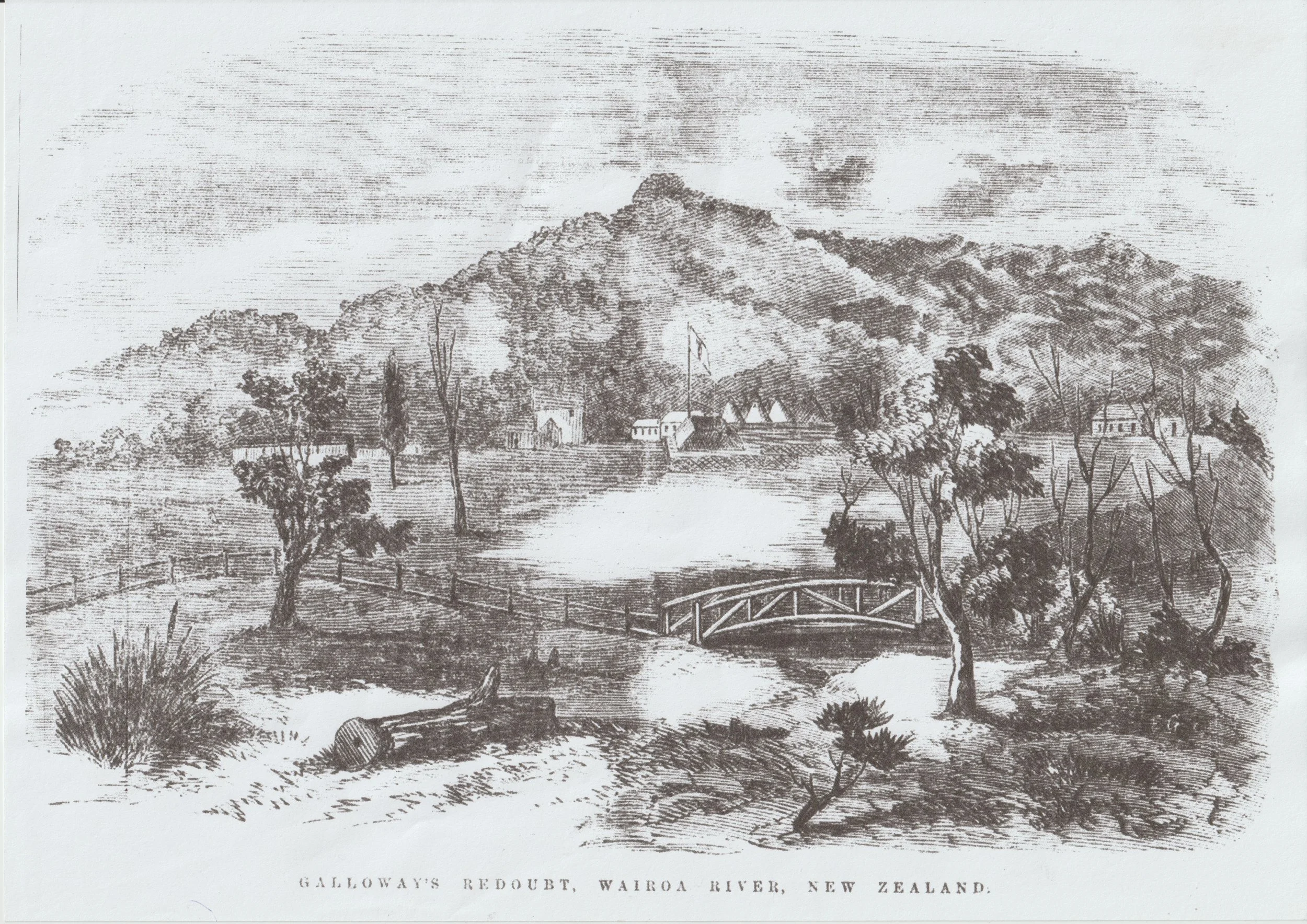
Galloway Redoubt
Galloway Redoubt
49 North Road
Trail marker #7
It’s a peaceful spot today, but in the 1860s this site was a military outpost during the New Zealand Land Wars.
Galloway Redoubt, as it was known, was one of five redoubts built east to west along the foothills of the Hūnua Ranges. Troops posted to the fortified Clevedon outpost were part of the greater Auckland defence force armed with muskets to protect the city’s southern boundaries during the war. It was built to house 200 militia from the 18th Royal Irish regiment, who were reinforced by troops from the 65th Regiment Rifles and volunteers. Along the brow of the hill facing the river was a system of trenches. From a sketch done at the time, the military encampment appears to have been on the flat across the gully directly opposite the main Church gates. Traces of the redoubt can still be seen on the site of the old vicarage next door.
A stockade was also constructed by what is now the McNicol Homestead and Museum, and trees were cleared to enable a clear line of sight between the stockade, the redoubt and the homesteads of the McNicol, Wilson and Thorp families.
The barracks were eventually demolished and the land was used as a church ‘car park’ – for horses and carts.
In the 1920s the vicarage was built on the site of the redoubt. Local legend has it that the vicar moving into the new vicarage was also gifted a horse, presumably so he could visit parishioners.
-
As tensions began to simmer in New Zealand, local iwi including Ngāi Tai, Ngāti Paoa and Ngāti Whanaunga tried to retain a neutral status. They were all involved in Auckland commerce and were also more exposed to colonial oversight than inland iwi. Despite this, in the years prior to 1863 “a cloud of mutual wariness settled over both Ngāi Tai and Ngāti Paoa and their Wairoa Pakeha neighbours, despite parallel and sometimes intersecting lives” (VB, p. 126).
In July 1863, Governor Grey had ordered all Māori living between Auckland and Waikato to take an oath of allegiance to Queen Victoria or be compelled to vacate the territory. Ngāi Tai determinedly remained neutral, staying at Umupuia; however, some of the tribe did join the rebellion.
The first settler deaths in Wairoa came just a fortnight after Grey’s proclamation; Charles Cooper was shot while bringing his cows in for milking in Ardmore, while 16 year old Sylvester Calvert was fatally wounded when a party of Māori attacked his family’s home, likely in retaliation to the Calvert family’s raiding of a seemingly abandoned nearby kāinga.
The disruption to settlers was quite major; families were driven off their farms, wives and children moved as refugees to safe havens in Auckland and the stockade provided sanctuary at night for those left behind.
By September active fighting had ensued, with many homes plundered and damaged. On 15 September the McNicol Homestead was attacked and the life of 8 year old Archie McNicol - who was out collecting turkey eggs - was only just spared when a shot took a piece out of his cap. The McNicols rushed to the Stockade ‘under a shower of bullets’. After two hours the attackers dispersed.
In retaliation the next day, ‘wet, cold, windy and disagreeable’, 70 soldiers and settlers accosted a large body of the enemy at the unfortified kāinga of Ōtau. They fired on about 20 of them and “brought two of them down”. A small detachment returned to Ōtau before sunrise the next day, opening fire on the village where up to 200 people, including women and children, were residing. Upon later inspection “the whares were riddled with bullets, and the profusion of bloodstains, both inside and out, testified to the native losses”. Māori deserted the settlements of Ōtau and Te Urungahauhau, retreating into the Hūnua Ranges. Settler families gradually returned to their ransacked homes but the hostilities and war mentality continued with more pillaging and lives lost across the region until hostilities ceased in 1864.
(VB, p. 145-147)


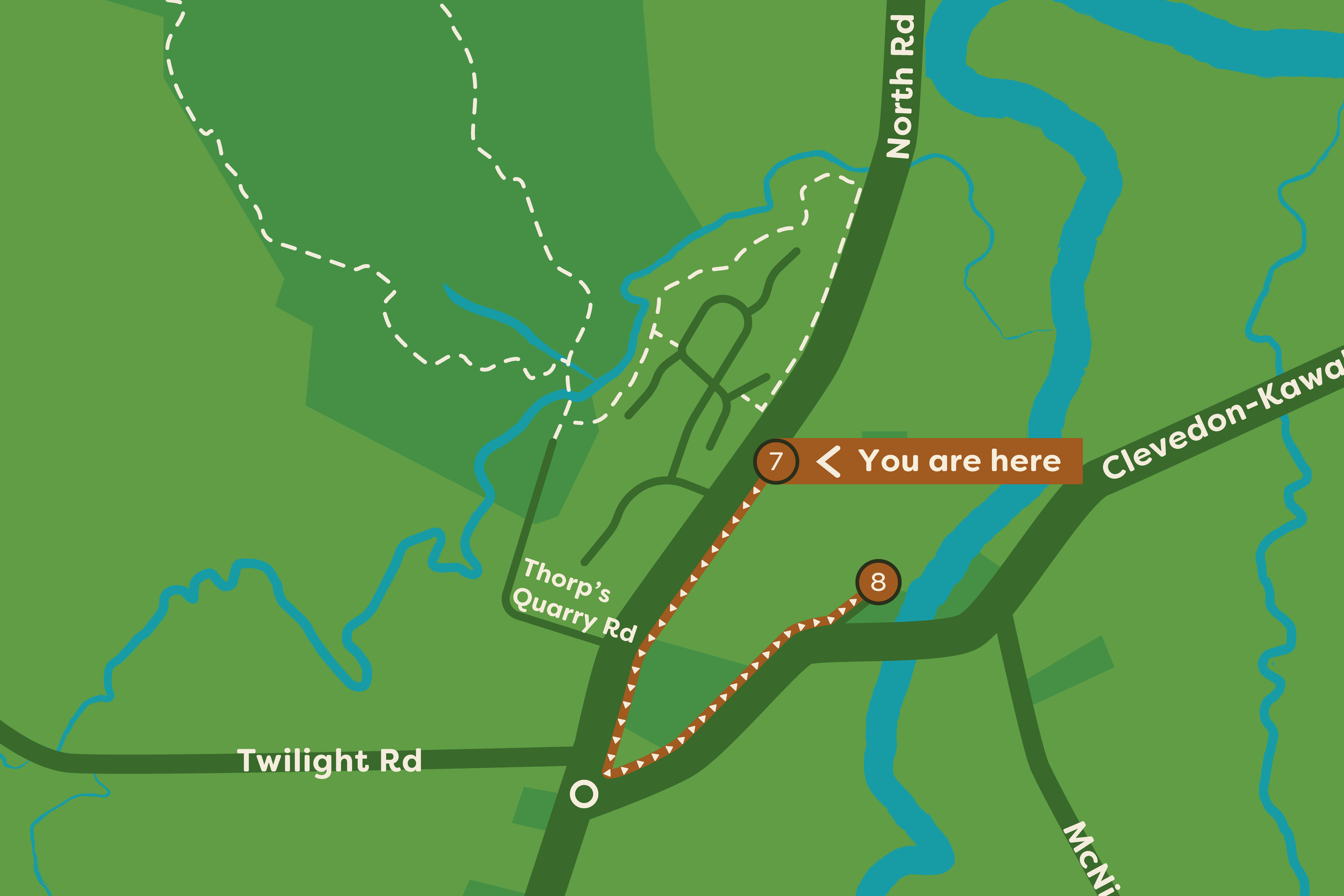
Location Map
You are currently at Heritage Trail Location #7, Galloway Redoubt
Ready to see the next site? Follow the path highlighted on the adjacent map or follow the directions below to reach your next location:
Wairoa River (approx 1.25km)
-
Next site:
Wairoa River (approx 1.25km)Travel south along North Road to the roundabout (approx 650m), passing private homes and commercial properties of historical interest including the old Vicarage, Thorp Cottage, Patton’s Stables. At the roundabout turn left down Clevedon-Kawakawa Road. Continue east past Clevedon School to the Clevedon Wharf Reserve. Enter via the driveway. The site markers for the next three sites are located on the wharf structure.

The information for each site has been thoughtfully prepared in collaboration with the Clevedon Districts Historical Society, drawing on Voices of Belonging by Jessie Munro, Yesteryears by F. Murray, and records from the McNicol Homestead Museum. Together, they tell the story of Clevedon and the people and places that made it the community we know today.
A special acknowledgement to photographer Donna Jepsen for her work capturing these sites as they appear today.
-
“Voices of Belonging”, Jessie Munro, 2016. Available to view and purchase at McNicol Homestead and for loan from the Clevedon Rural Library.
“Yesteryears”, Fraser Murray, 2009. Available to view and purchase at McNicol Homestead.
The Archeology of Clevedon Village and Wairoa River Valley, Opus.
The History of Clevedon School
An broad overview of our local history is available at clevedon.co.nz
Ngai Tai ki Tamaki’s history is rich and detailed in a number of online records;
• Ngāi Tai ki Tāmaki website (“Our Stories”)
• Ngāi Tai ki Tāmaki’s Deed of Settlement (Section 2.0 Historical Account)
• Clevedon School 150 year anniversary summary